Delaware County Library: Liberty Branch Bicycle Service Area Analysis
Quantifying the residents, households, and children impacted by the lack of safe bicycle and pedestrian access along Steitz Road.
419
Households
within 2 miles
1,180
Residents
across two townships
318
Children under 18
within service area
< 10 min
By bicycle
2 miles or less
An estimated 1,180 residents, including 318 children under age 18, live within a 2-mile, sub-10-minute bicycle ride of the Liberty Township Branch Library — but lack a direct and safe bicycle/pedestrian connection.
What the data tells us.
- This is not a distance problem. It is a safety and access gap.
- The library is close enough to reach, but not safe enough to access.
- More than 1,100 residents live within practical bicycling distance.
- More than 300 children live within the service area.
- The current alternative requires crossing Steitz Road twice — even though the library sits on the same side of the road as the impacted neighborhoods.
Who lives within the service area.
Service area by township
Households
Total 419
- Concord Township335
- Liberty Township84
Residents
Total 1,180
- Concord Township943
- Liberty Township237
Adults
Total 862
- Concord Township689
- Liberty Township173
Children
Total 318
- Concord Township254
- Liberty Township64
Residents by township
- Concord Township80%
943 residents
- Liberty Township20%
237 residents
How quickly residents could reach the library.
Proximity rings
Households by bicycle distance
Shading deepens outward — the 2.0 mi band reaches the most residents (1,180).
Cumulative reach
Each ring widens the safety dividend.
Every additional half-mile of safe connection unlocks meaningfully more households, residents, and children — a small infrastructure investment with compounding civic returns.
- Within 0.5 miles
- 121 residents
- Within 1.0 mile
- 197 residents
- Within 1.5 miles
- 848 residents
- Within 2.0 miles
- 1,180 residents
Within 0.5 miles
43
households
- Residents
- 121
- Children
- 33
Within 1.0 mile
70
households
- Residents
- 197
- Children
- 53
Within 1.5 miles
301
households
- Residents
- 848
- Children
- 228
Within 2.0 miles
419
households
- Residents
- 1,180
- Children
- 318
Full service area
70%+
of identified households live within 1.5 miles of the library.
848
residents — including 228 children — live within 1.5 miles.
120+
residents live within practical walking distance (0.5 mi).
The problem isn't distance. It's the route.
Direct Steitz Road Connection
Safer, shorter, more intuitive
- Library and impacted neighborhoods are on the same side of Steitz Road
- Avoids unnecessary roadway crossings
- Provides a safer and more intuitive connection
Liberty Grand Alternative
Longer, exposed, two crossings
- Requires crossing Steitz Road twice
- Steitz Road is posted at 45 MPH
- Adds 0.3 miles to the trip
- Adds ~20% to the trip for Harvest Curve and Scioto Reserve residents
- Introduces unnecessary conflict points with vehicle traffic
"Residents are being asked to cross a 45 MPH roadway twice to reach a destination that is already located on their side of the street."
A direct Steitz Road connection.
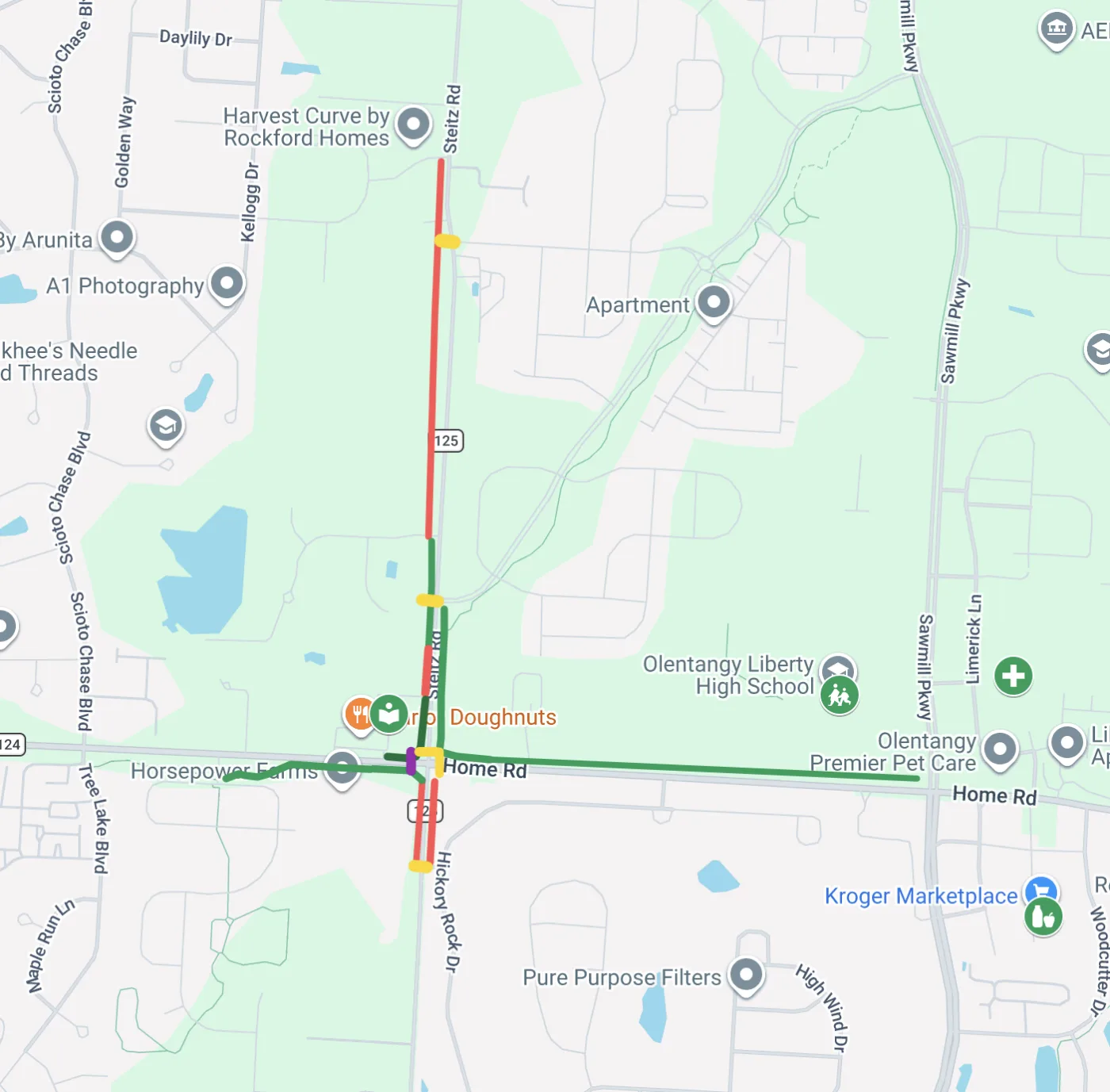
Same-side connection along Steitz Road.
Build a continuous pedestrian/bicycle facility along Steitz Road so residents can reach the library on the same side of the road they already live on.
- Distance:
- ~1.5 mi
- Road crossings:
- 0
- Distance:
- +0.3 mi
- Crossings of 45 MPH road:
- 2
The recommended route is shorter, removes both 45 MPH crossings, and ~20% faster for Harvest Curve, Harvest Point, Steitz Road and Scioto Reserve residents.
The library is more than a building.
The Liberty Township Branch is a public asset whose value depends entirely on whether residents can safely reach it.
The current lack of a direct bicycle and pedestrian connection along Steitz Road limits safe access to a major public asset for hundreds of nearby households.
A direct connection would improve accessibility, reduce roadway crossings, and provide a safer route for residents in both Concord Township and Liberty Township.
How the analysis was assembled.
Delaware County Auditor GIS
Residential parcel data within the study area
U.S. Census Bureau Geocoder
Address geocoding and Census geography matching
U.S. Census Bureau
Demographic data for population and age estimates
Geoapify Routing API
Bicycle distance and travel-time calculations
All counts are estimates derived from public parcel records and Census demographic data. Travel-time figures reflect typical bicycle routing along available roadways.